Sneak Peak at one of our Lunch Auction Items....
ORCV Overview
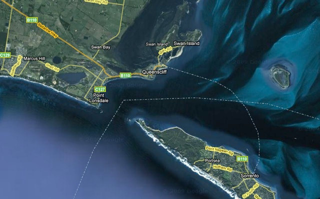
We conduct a regular, on-water practical tour of the entrance to Port Phillip Bay. The ‘pincers’ of the two peninsulas are known collectively as The Heads and comprise of Point Lonsdale in the West and Point Nepean in the East. The Rip is the passage of water between these two points.
We conduct a regular, on-water practical tour of the entrance to Port Phillip Bay. The ‘pincers’ of the two peninsulas are known collectively as The Heads and comprise of Point Lonsdale in the West and Point Nepean in the East. The Rip is the passage of water between these two points.
During the ORCV Rip Tour, very experienced offshore navigators and yachtsmen provide expert commentary. This makes for an informative and enjoyable day for all yachties and their families. Since it's beginning, the Rip Tour has grown in popularity with all manner of boaties, fishermen, historians, beach walkers, surfers and holiday makers alike, so come along and get set to enjoy a memorable day out on Port Phillip Bay. Please also remember that this is an on-water, outdoor activity that is subject to weather conditions and sometimes postponements, so your co-operation and understanding is very much appreciated.
‘The Rip’ is the narrow entrance to Port Phillip Bay and the only access for shipping to the ports of both Melbourne and Geelong. More than 4,000 commercial vessels transit this gateway annually, where underwater reefs limit the navigable entrance to just 0.6 of a nautical mile.
This narrow entrance acts to restrict the tidal flow within the Bay, which holds some 25km3 of water therein and sets up a difference in the relative water levels between Port Phillip Bay and the Bass Strait. Consequently, the tides can run very fast in both directions and when you add some of the strong winds the area is famous for, it all brings about some very interesting and precarious conditions, where the tide can be up to six knots and the water can stack up to over a metre and sometimes three!
The Heads are governed by the Port of Melbourne from Point Lonsdale Light, more correctly known as Point Lonsdale Signal Station or Lonsdale VTS (VTS = Vessel Traffic Service). They close the Heads when conditions are unsuitable.
Outcomes
To provide for well planned and executed transits of Port Phillip’s Heads, with an emphasis on doing so in low-powered vessels (like yachts) and provide information to participants on the numerous navigational aids and strict procedures required for safe passages through.
• Knowledge of safety procedures
• Identification of navigational aids
• Familiarisation of the leads and use of safe water channels
• Understanding radio protocols
• Awareness of expected inbound and outbound traffic and obligations
• Confidence in traversing The Rip either during day or night with identification of leads and tidal flow
• Weather conditions and their effect on tidal streams
Rip Tour Content
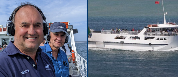
This course begins when the ORCV vessel steams from Sorrento Pier to collect the other passengers from Queenscliff, where there will be commentary on certain key elements of the area. Once the other passengers have boarded, the instruction by experienced offshore navigators and yachtsmen will begin. This covers:
• Underwater topography
• Points of interest
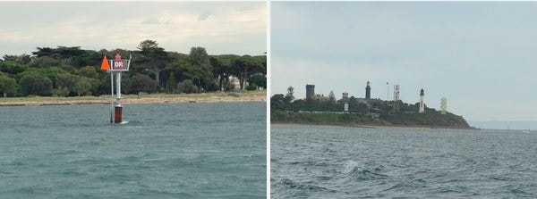
• Major channel beacons, marks and navigational aids
• Traffic data and radio protocols
• Queenscliff lead lights and shipping channels
• Tides and tide signals
• Identification of safe conditions and/or dangers
• How to perform a correct and safe passage in both directions
• Pertinent historical facts and points of interest
From the instruction, you will learn about patterns in tidal flow, how to set up for safe transits of the Rip and experience the correct channel protocols in use. Favourable conditions will either be observed or described depending on the day, as well as learning how to anticipate and therefore avoid, dangerous situations.
You will also traverse the leads under Shortland Bluff and depending on tide and traffic, there may be the opportunity to venture seawards to view the effects of ‘The Rip’ before returning to disembark at your nominated port.
During the course, all participants will receive a copy of ORCV’s Rip Guide.
‘The Rip’ is the narrow entrance to Port Phillip Bay and the only access for shipping to the ports of both Melbourne and Geelong. More than 4,000 commercial vessels transit this gateway annually, where underwater reefs limit the navigable entrance to just 0.6 of a nautical mile.
This narrow entrance acts to restrict the tidal flow within the Bay, which holds some 25km3 of water therein and sets up a difference in the relative water levels between Port Phillip Bay and the Bass Strait. Consequently, the tides can run very fast in both directions and when you add some of the strong winds the area is famous for, it all brings about some very interesting and precarious conditions, where the tide can be up to six knots and the water can stack up to over a metre and sometimes three!
The Heads are governed by the Port of Melbourne from Point Lonsdale Light, more correctly known as Point Lonsdale Signal Station or Lonsdale VTS (VTS = Vessel Traffic Service). They close the Heads when conditions are unsuitable.
Outcomes
To provide for well planned and executed transits of Port Phillip’s Heads, with an emphasis on doing so in low-powered vessels (like yachts) and provide information to participants on the numerous navigational aids and strict procedures required for safe passages through.
• Knowledge of safety procedures
• Identification of navigational aids
• Familiarisation of the leads and use of safe water channels
• Understanding radio protocols
• Awareness of expected inbound and outbound traffic and obligations
• Confidence in traversing The Rip either during day or night with identification of leads and tidal flow
• Weather conditions and their effect on tidal streams
Rip Tour Content
This course begins when the ORCV vessel steams from Sorrento Pier to collect the other passengers from Queenscliff, where there will be commentary on certain key elements of the area. Once the other passengers have boarded, the instruction by experienced offshore navigators and yachtsmen will begin. This covers:
• Underwater topography
• Points of interest
• Major channel beacons, marks and navigational aids
• Traffic data and radio protocols
• Queenscliff lead lights and shipping channels
• Tides and tide signals
• Identification of safe conditions and/or dangers
• How to perform a correct and safe passage in both directions
• Pertinent historical facts and points of interest
From the instruction, you will learn about patterns in tidal flow, how to set up for safe transits of the Rip and experience the correct channel protocols in use. Favourable conditions will either be observed or described depending on the day, as well as learning how to anticipate and therefore avoid, dangerous situations.
You will also traverse the leads under Shortland Bluff and depending on tide and traffic, there may be the opportunity to venture seawards to view the effects of ‘The Rip’ before returning to disembark at your nominated port.
During the course, all participants will receive a copy of ORCV’s Rip Guide.
Qualifications
The ORCV requires the sailing master of any yacht entering an ORCV race for the first time to have demonstrated an understanding of navigation protocol at Port Phillip Heads, either from experience within the last six months or by completing this course.
The ORCV requires the sailing master of any yacht entering an ORCV race for the first time to have demonstrated an understanding of navigation protocol at Port Phillip Heads, either from experience within the last six months or by completing this course.
Course Registration Information
This course is weather dependant and requires a minimum number of participants to go ahead. If unsuitable conditions are forecast, registered participants will be notified by telephone on the morning of the scheduled tour.
Bookings are essential, as there is a limit on the number of passengers the vessel can take.
We require one registration for each person accompanying you, as this also allows us to inform all of you if there is a postponement due to weather or the like.
For your convenience, you can board from either side of the Bay in Sorrento or Queenscliff. Click here for a map of both boarding locations. You must nominate which Boarding Location you would like to embark/disembark from when you register. The ORCV vessel will be departing on time, so please ensure you are ready to go, ahead of schedule.
Once you have boarded, you should NOT disembark until after the tour is completed and only disembark at the scheduled times in Sorrento and Queenscliff. Toilets and cafeteria are located onboard for your convenience. Timing of the tour is critical including scheduled arrival at the Rip near Slack Water. The ORCV will not be responsible for anyone who is not onboard by the scheduled departure times.
What to Bring• Weather appropriate clothing including non-slip footwear
• Snacks and water
• Binoculars, notepads, Dictaphones and cameras are optional at your discretion
• Life jackets will be available on board
Course PresentersVery experienced ORCV offshore navigators and yachtsmen will provide not only commentary, and will also highlight points of interest, provide aide-mémoires and include any pertinent historical facts or points.
Location InformationA boarding location map of Sorrento Pier and Queenscliff Marina can be found HERE. Please remember to be ready ahead of time as the vessel is on a strict timeframe.
"Transiting the Rip". An article written by ORCV Member, Nick McGuigan, for the 2010 RBYC Short Tacks magazine. Click HERE.
If you have a question, please email us at [email protected] or alternatively, phone 0493 102 744
 RSS Feed